After traversing the southern states, driving the length of the Natchez Trace and making our way to Nashville, we decided to continue east towards the coast to travel south to Florida. Next year, we’ll travel from from Florida inland through some of the states we’ve visited and then continue north. So with plan in mind, we began aiming east. Along the drive we stopped for a walk to the viewpoint of the Linn Cove Viaduct, the first bridge of its type to be built in America. Using computer technology, the bridge was built with minimal disruption to the surrounding area, preserving the flora and fauna.


And then we came to the spectacular Linville falls.
The volume of water rushing down was huge and you could see the upper cascade where it flowed behind the rock wall face before tumbling over the escarpment.

The information board at the start of the short hike promised wonderful views of the valley below and we weren’t disappointed.

Then a short distance along provided another viewpoint of the falls.

Continuing down along the trail, we made our way to the bottom of the waterfall.


There were three hikes to view the falls, none of which were particularly long, but all had spectacular views.


Peter checking the direction we should be headed on the Strava App.

Along the trails, tucked in amongst the green, there were some beautiful blooms.


One of the things I like about roads like the Blueridge Parkway, is the many opportunities for hikes along the way. There are trail heads quite regularly that provide a variety of length trails and all have spectacular scenery.

We whose the Hawk’s Bill Rock hike and, as we’d come to expect in this region, it was mostly uphill.


There were beautiful flowers that added colour to the green, the birds were singing and the scenery at the top was spectacular.

Peter sitting on the Hawk’s Bill Rock

Our next stop was Craggy Gardens. We were there at the right time of year to see the Rhododendrons in full bloom, however, they were a little later blooming this year due to the cold weather they’d had, so many were still in bud or with only a few blooms showing their wonderful colour.


Still, the views were spectacular.


Not long after leaving this area, we crossed into Virginia.


As we drove, with no particular destination in mind, just heading east, we traversed another of these bridges that are quite steep to allow boats to travel underneath. We would realise once we arrived at the coast that tall, steep bridges like this are very common. I discovered that this region contained a number of antebellum mansions that gave tours. Shirley, was the oldest dating from the early 1700s, so we googled directions. We drove down a very narrow dirt road that both google maps and the signs on the road, indicated was the right direction. We arrived at a locked gate with CLOSED emblazoned across it. Disappointing, because there their website gave no indication of hours of operation. We discovered later that they have a restaurant and winery, but that the family who own it, actually live in the house, so tours happen twice per year and are booked out as soon as tickets open.
Not to be deterred, and not far back I’d also seen signs to an estate called Berkeley. Google provided me with directions and confirmed that they were open for tours. Berkeley is the second oldest antebellum mansion in the region, dating from 1723.
This sign greeted us at the entrance to the driveway.

Clarence, who hosted our tour of 6 people was the best tour guide we’d had so far. Very entertaining and incredibly knowledgeable. We didn’t get the impression that he was parroting what he’d learned but that he really knew everything about the house, the people who lived there, and the area. He must have been 70 years old if he was a day! He was rake thin, and dressed in period costume. A thick, double-breasted linen shirt and brown knickerbocker pantaloons with a double buttoned front.


Berkeley is situated on the James River, on 1,000 acres of land that are still farmed today. According to Clarence, the first 10 presidents of the United States danced on the timber floors that are still all original from its construction in 1726. Berkeley historical information contentiously, also disputes the claim of that the first Thanksgiving took place in Plymouth. They argue instead, that it occurred in 1619, over a year earlier on the banks of the James River, where Captain John Woodlief landed with a small party of men, named the land Berkeley, and held a service to thank God for their safe journey.

One of the first shipyards was build on the River at Berkeley in 1621. The plantation house was built by Benjamin Harrison IV, a wealthy and prominent Virginian and lived in by generations of the Harrison family. His son, Benjamin V, a staunch patriot, was Virginia’s fifth governor, a Virginia delegate to the Continental Congress and a signatory on the Declaration of Independence. Berkeley was also the home of the US’s 9th president, William Henry Harrison, who also has the dubious honour of being the shortest reigning President, from 4 March – 4 April, 1841, when he died.
Like many of these grand homes however, it has had a checkered past. During the American Revolution (1775-1783), 18 warships were built at Berkeley ship yards, making it a target for the British. The family moved out, fearing reprisals and these came with the arrival of the traitor, Benedict Arnold and the Redcoats who set fire to all the furniture in the house and razed the crops and outbuildings. Because of its sturdy brick outer however, the house remained standing. The Harrisons returned in 1784 and spent 4 years restoring the house and land.

Originally a tobacco plantation, during its height, 110 African slaves worked on the property. Poor farming practices however, caused crop failures and the last of the Harrisons, Dr. Benjamin Harrison VIII, gave up the property in financial ruin in the mid 1800s. During the American Civil war, the manor and land hosted 100,000 Union soldiers. Clarence explained that for the second time, everything in the house was burned by the soldiers for fires and when they left, the house fell into ruin for 50 years.

Berkeley also boasts that while stationed there, General Daniel Butterfield wrote the army’s first official bugle call, “Taps.” “Taps” was first commissioned to play at the burial for a soldier but from 1891, it has been played at military funerals and evening flag ceremonies on military bases.

John Jamieson purchased the property in 1907 and his son Malcolm and daughter-in-law Grace spent years restoring it. Clarence told us that Malcolm was very eager to host tours of the manor, but Grace was vehemently against it. Malcolm won out, and the first tours began in 1938 under the proviso from Grace that every tourist must be gone by 5pm and they were not to be allowed in the upper floors. If Malcolm got carried away and let a group stay past 5pm, Grace would bang on the wooden floor upstairs until the people left.

While beautifully furnished with antique and period furniture, none of it is original to the house. When Grace and Malcolm began their renovations with the intention of living in the house, they purchased every piece of furniture from the adjoining manor, whose furniture had been spared because of their allegiance to America.

Although all the outbuildings and slave accommodation was destroyed during the Civil War, there are 2 accurate representations of slave quarters on the property, a legacy of the 2018 biographical film Harriet, on the life of the abolitionist, Harriet Tubman.


The grounds are quite magnificent, having been restored to their former glory.


Our next stop was Jamestown Mariners’ Museum and another surprise. At $1.00 each for entry, that’s not a typo – $1.00 per person, this museum is fantastic. We arrived as they opened at 9am, left to grab coffee and for lunch, but otherwise, spent the best part of the day!

One of their main drawcards is the USS Monitor and the Batten Conservation Complex which is, according to the brochure, “part of the world’s largest marine archaeological metals conservation facility,” housing more than 210 tons of artifacts.
The USS Monitor was an ironclad war ship, one of the first built from iron, not wood and using steam, rather than sail power. It was used during the Battle of Hampton Roads on March 9, 1862! I had no idea that vessels were this technologically advanced so early.
The Monitor sank during a storm on December 31, 1862 and sits on the ocean floor off North Carolina’s Outer Banks. However, the wreck was discovered in 1973 and a team of ocean archaeologists were able to raise a number of artifacts, the largest being the Monitor’s 115 ton revolving gun turret, 2 Dahlgren guns and its steam propulsion engine. All of which are on display in the museum.
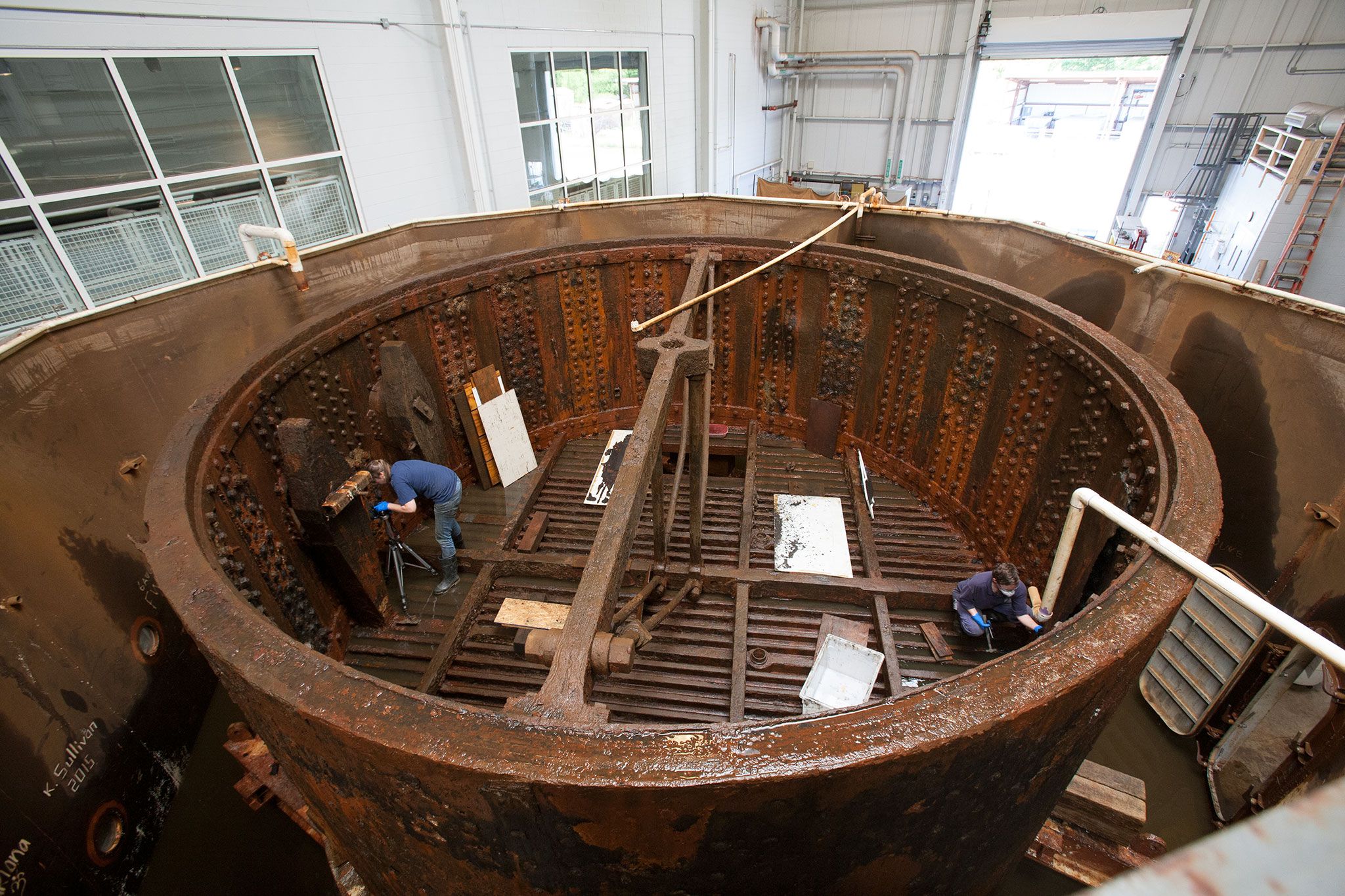
This image is from the museum website and it gives an idea of the size of the turret. In the museum, any angle for a photo just looked like some dark metal but it was fascinating to walk around.
Although the remains of the ship are still under the ocean, a number of interesting items that were recovered in the turret are also on display, including a sailors wool jacket, shoes, coins and a knife.
But that’s just one room in the museum, of 12 rooms!
The ship model gallery was amazing! There are a number of people whose hobby is recreating to scale model ships and the detail is unbelievable. There were 2 model makers working when we toured and we spend quite a while chatting to them about the intricacies and details they go to, to replicate these ships. On average, depending on the model, they can take between one and two years to complete and they make every piece from scratch.
The models below, which are a small selection of the 35 on display, were the life’s work of August and Winnifred Crabtree. They follow the history of boating and every one is to scale, intricately carved and with working parts. August, born in 1905, began as an actual ship builder and then built model ships for Hollywood. There are models from a primitive raft to a 15th century Spanish galleon and more modern ocean liners. They were very difficult to photograph because of the lighting and the fact they were all behind glass cases.

SS Howick Hall, 1910

Egyptian Seagoing Vessel, circa 1480 BC

Roman Merchant Ship circa 50 AD

Santa Maria, Christopher Columbus’ flagship, 1492
The other area we found very interesting was the International Small Craft centre, a huge warehouse-sized room that housed actual boats that varied from canoes, to small yachts, to motor boats.

For example, this Bull Boat, circa 1939, came from the Hidatsa Nation, North Dakota and is a traditional canoe made from buffalo skin stretched over willow saplings.

An asymmetrical gondola, from the mid-nineteenth century which is one of only a handful that were built to offset the gondolier’s weight.

A Catboat, circa 1927, this actual boat was sailed on the Amazon.

Any James Bond fans will recognise this boat from the classic Roger Moore scene where they race these boats down Venice canals in For Your Eyes Only.
The maritime museum is not the only attraction in Jamestown however, and since we spent almost an entire day at the maritime museum, we stayed to visit the park and the other historical sites the following day. One of the benefits of travelling the way we do, we can stay as long as we like and change our itinerary at the drop of a hat. So, the following day we visited Jamestown Island, the Yorktown Battlefield archaeological park and the Archaearium Archaeological Museum.

Established in 1930, the park preserves sites of English colonisation from the 16th and 17th centuries and the American Revolution.


We walked around Jamestown Island off the Colonial Parkway early in the morning and happened upon the glassblower, setting the furnace for later demonstrations. This is a recreation of a 17th century glass furnace, complete with the artisan who fashions glass objects using the same tools and techniques as they did centuries ago. Not the place to work on a warm day however!


When the turtles are mating and moving around more, they close the roads to traffic so they don’t get run over.


And there’s always a cute squirrel, just waiting for a photo!

I had to sneak in another cute squirrel photo. This one was enjoying his breakfast. There were also heaps of Fiddler crabs. We learned that only the males have the large claw. Don’t be concerned by the size of the crab in the photo, though, the largest ones are actually only about the size of a finger joint.

The archaeological and battle sites were a mixture of recreations, restorations and archaeological ruins. Because it’s now America’s summer break, schools and universities have several months off so there were budding archaeologists on a camp, assisting with a current dig.

Recreated galleons


The first settlers arrived here in May 1607 in 3 wooden ships. Soon thereafter, the 104 men were besieged by Natives so one of their first tasks was building a wooden fort. Its recreation is on the site but this was one of many challenges. They found ample water from snow run-off initially but as summer came, the fresh water dried up and wells, contaminated with salt water, became unpotable.


However, the cedar, walnut and sassafras trees they felled for building timbers was considered lucrative and until 1620, it was shipped back to England when the cost exceeded the profit and they turned to harvesting tobacco.


Some of the excavated ruins from the first settlement

A recreation showing what the timber fort looked like and its positioning on the site, determined by the archaeological dig.
The first 3 ships that arrived from England held only men but eventually they realised that the jobs women completed and indeed, the ability to further the colony, relied on women. In 1620, 2 ships arrived containing 90 women recruited by the Virginian Company expressly to wed the settlers. The women were skilled in brewing, baking, sewing and of course, they bore children.
At this time also, several dozen “captive Angolans” were landed in the colony and became the first slaves. In fact, archaeologists have discovered information about an African woman named Angela, one of the first whose identity has been revealed and who lived in the settlement in 1625.


By then too, the settlement had the resemblance of England, with habitable houses, livestock, crops and the variety of artisans required to supply all the needs of a growing town. Including government. The settlers chose Captain John Smith as their governor in 1608 and the first General Assembly met in the church, originally a wooden structure, the first brick church was constructed in 1639, this renovated church is circa 1750.


The Jamestown settlement is also where, in 1614 John Rolfe, who is credited with the development of the tobacco crop in the settlement, married Pocahontas, the daughter of the Powhatan chief and which enabled a relative peace between the native people and the settlers. According to accounts by settlers however, Pocahontas had many interactions with the new arrivals from her childhood, and as the daughter of a chief, had managed to save and free a number of captured English settlers.
She gave birth to a son and in 1616 the family and a number of Powhatan men travelled to England with the aim of advertising the colony and encouraging more settlers. Just as they readied to return to Virginia, Pocahontas became ill and died suddenly. She is buried at St. George’s church, Gravesend. Rolfe returned to Virginia, leaving his son Thomas in England.

This bronze statue is a representation of Pocahontas, as there are no images of her.
After another full day in Jamestown we were ready to set off again. As I mentioned, we decided to take the coastal route south and saw this rather bizarre sight, travelling along the road. You might be able to guess what’s in the barrels from the second, close up photo. We assumed they were alive.


Although, their contents shouldn’t be surprising, just the manner of their travel. Crabs seem to be a culinary mainstay here. The whole way along the coast, we’ve seen very many cafes, restaurants, shacks and eateries that owe their existence to to the abundance of and culinary delights that crabs provide.
Initially, driving through areas like this was quite the novelty. Travelling along miles and miles of roads and bridges that traverse waterways on both sides like this, is not something we see in Australia. But, by the time we were traversing the Outer Banks, we’d grown accustomed to roads like the one below, which brought us to a lovely little town with a boardwalk along the Intracoastal Waterway and a very odd name.

I had to post this picture because I’m sure nobody would believe the town was actually called Duck! We had crossed the border again and were now in North Carolina. According to the historical information, it’s a very popular seaside destination and was only incorporated in 2002. Apparently, it’s a popular duck hunting region and as everybody referred to the location as “Duck” the name stuck.


These posts are installed specifically for the birds and this one had a chick

We never discovered why there were painted horses scattered around the town, rather than, oh I don’t know – maybe ducks?


As well as the very picturesque boardwalk, they had a wonderful bakery with donuts the size of…..

Well, you can see how big they were!
Not terribly far down the coast we arrived at the Wright Brothers Park, the location of Wilbur and Orville Wright’s historic first flights. However, if you didn’t know, you wouldn’t guess what this actual location is called.

Would you believe, Kill Devils Hills? This is the actual location where Orville and Wilbur Wright tested, modified and eventually managed free flight of a “heavier-than-air machine” for the first time.

In fact, these markers delineate exactly where they took off from and landed their first three successive flights.


The monument was erected in the Wright Brothers honour in 1932, and a recorded 2,000 people attended the dedication. A far cry from the few locals who helped them achieve their goal in 1903.


This is an exact replica of the plane, showing one of the locals who helped steady it, as it took off.
Nearby, we took a walk in the surrounding sand dunes to see the biggest dune in the area, and we traded photos with another tourist family.

Then, we continued our drive along the coast on Highway 12, the narrow land spit along the Outer Banks and enjoyed the varied scenery.


Each of the Lighthouses along the coast are painted differently to assist daytime navigation.


As you can see by the pictures, it was very scenic but also very varied. The other thing we’ve noticed travelling here, is the amount of unusable land. so much of this area is water and it’s flat. There’s barely a hummock, except for the very steep bridges that traverse the waterways to enable large ships and yachts easy passage along the Intracoastal Waterway. And these dunes, that vary with the wind.

There are a number of bridges along this 70 mile stretch of highway and the roads are barely above the waterline. There are also two car ferries. The first is a free ferry and takes about 20 minutes to traverse the water.

The first ferry takes you to Ocracoke Island then you drive across the island to the second ferry which takes 2 1/2 hours to Cedar Point. This one cost a reasonable $32 for Joey.


Ocracoke Island is famous for its wild ponies, although they aren’t so wild now. They have fenced in yards and are fed and cared for. Apparently, too many were hit by cars on the road so they decided to contain them. The 3 that we saw were very fit and healthy.


We also managed to be on the island when they were holding an annual music festival, so it was quite busy in the little town. We walked the length of the town and to the original lighthouse. Constructed in 1823, it’s the oldest functioning lighthouse in North Carolina, although today, the light is automated.


We spent the rest of the day listening to the music we could hear from Joey, while we waited for our 5.30pm ferry departure.


The road from Cedar Point was not dissimilar to the island roads and we had a wonderful sunset.


And a beautiful sunrise.

I need to digress for a moment, and ask a question. Have you ever been misplaced because you thought you were going to a specific place and found, when you arrived, that you weren’t where you expected to be? Let me be more specific. We’ve just arrived at Beaufort, a small town not far from the Cedar Island ferry landing. But as I perused my map, I discovered that Beaufort was actually in the next state, South Carolina. Couldn’t be! Time to check our more detailed map, and lo and behold, there’s the other little town called Beaufort. There are, it seems, more often than you would think, more than one location with the same name. This isn’t the first time we’ve been bamboozled with towns of the same name being in different places. Years ago, before GPS, we were in England searching for the motor racing circuit at Donnington. We asked directions and found it. Unfortunately, we also discovered that there were actually three Donnington’s in England and we were at the wrong one!
So, here we were, in North Carolina’s Beaufort.

We continued to hug the coast on the way south, and this Beaufort was another quaint seaside fishing town, with some cute bird houses on stilts and if you look closely, you’ll recognise that they seem to be made from eskies.


We discovered that from 1769, Beaufort was a part of the Trans-Atlantic slave trade, which landed Africans bound for plantations along the length of the coast. In fact, it is registered as a slave route with UNESCO.
As we walked around the town, we passed some lovely homes, churches and buildings with, as we’ve come to expect, a very long history.


For example, this very old graveyard, or burying ground.


Morehead City was our next stop, a larger seaside fishing town, swelling with fisherfolk attending the annual Big Rock Marlin Tournament.


Our camp for the night, south of Morehead City, was Cedar Point, a park surrounded by marshes and swamps, so we had an interesting walk the following morning.


There were literally thousands of these Fiddler Crabs.


In many places we’ve walked, we’ve heard woodpeckers. They peck at the trees, searching for bugs below the bark and they can be quite loud. But we’ve never actually seen one. Walking back through the campground, we saw our first woodpeckers.

There were two on this tree and they were the funniest thing to watch. They pecked furiously at the tree, going round and round, back and forth. It was like they were testing the bark for insects before pecking a hole because they weren’t in one place long enough. Unless it was a mating ritual, considering there were two.
Our travels have been anything but boring. We’ve discovered such varied places to visit and activities to do. Looking for interesting things to do is what brought us to the USS North Carolina Battleship. This was another of those attractions we thought we’d spend an hour or so wandering around but instead, found it incredibly informative and were the last people left after closing time!


There were information boards throughout the 9 levels of the ship which appealed to both of us. Peter enjoyed reading all the technical information and I really related to the photos and transcripts from interviews by members of the crew who explained exactly what it was like living and working aboard, during active duty and also lulls where the crew had free time.
The USS North Carolina is moored across the Cape Fear River from Wilmington. Commissioned in April 1941, she participated in every major battle in the Pacific during World War II and has been restored as a memorial to the 2,000 men who worked aboard her and the more than 11,000 North Carolinians who lost their lives during the war. She has operated as a museum from 1960.


What made it particularly interesting, was that very little of the ship was cordoned off or out of bounds and most of the equipment was in working order and hands on. So we climbed into the gun turrets, adjusted and looked through the telescopes and sights and got a real understanding of the often cramped and stifling conditions under which the sailors worked. Remembering too, that they were also stationed in tropical waters. Our actual experience combined with the information and testimonies of the crew made this an experience we’ll remember.


We could easily have spent another hour looking through the bowels of the boat which was a real rabbit warren of corridors and interconnected rooms. When we realised the time, we were quite a few levels below in the ship and although we’d been following the tour and arrow signs, with only 10 minutes to closing time we thought we’d cut and run, so to speak. Bad idea! We came to dead ends, then tried retracing our steps and got befuddled again. I did start to wonder how on earth the staff would confirm that everyone had actually vacated. Initially, we saw a couple of other people but then, all of sudden, it appeared that we were the only ones left.
When we finally found our way to the up exit stairs and through the door onto the deck, I was quite relieved.
We overnighted in Wilmington and the following morning, took a very interesting walk around the town’s historic river district. Settled in 1725, by the time the railroad reached the town in 1840, it had grown to a bustling city, which included a number of beautiful buildings and manor houses. After the Civil War (1860-1865) it became a prominent centre for the region, encouraging more growth.
Like many of the towns we’ve visited, Wilmington has an active historical society and many of the home owners have ‘come to the party’, so to speak, and have renovated or maintained their homes immaculately.
We found ourselves crisscrossing up and down the streets, reading the historical information and taking in the varied architecture.


Before we left the Wilmington area, we took a walk along the river through the high rises to the beach.

We’ve seen these before where you pedal your way around a city while imbuing a large quantity of alcohol but we’ve never seen one on the water before.


A very industrious chap was pushing this cart with gelato along the sand. I guess the shops on the street were too far on a hot day.
But, time to move on. A short drive and we were at another ferry. This one a short distance like the first, and a nominal fee.

We arrived at lovely little town, saw some interesting sights, and bought some locally caught shrimp or prawns if you’re Aussie.


The fishmonger told us all about their pelicans, who are wild but come so regularly, they have names.
This house really attracted our attention because the fire engine red roof stood out against the crisp white so much. Then we discovered it was quite notable because it belonged to Captain Thomas Mann Thompson, “one of the most successful of the 77 licensed pilots who guided blockade-running steamboats through the Cape Fear Shoals during the Civil War”, to quote the information board.

Apparently knowledgeable pilots like Thompson were paid as much as $3,000 in gold per trip, and he piloted 9 different steamers over 34 successful runs, so it’s not surprising that he was able to build such a house in 1868.

I couldn’t resist a picture of this cute little vehicle. Something we’ve noticed here, is that golf buggies, sand buggies, all kinds of buggies, are able to drive on the roads and we frequently see them driving around resort areas, beaches and lakes. They’d never be allowed on the roads in Oz!

And just like that, we’ve crossed another border !
We found a lovely swamp and boardwalk and not far along, a very busy beach, lined with high rise accommodation and apartments.


We also discovered, if you like seafood it’s the place to find a buffet. There must have been a dozen or more so after some quick googling for reviews, we chose this one.


We were so spoiled for choice, and it was all delicious, what’s more, there was no time limit, which they like to impose on buffet’s in Australia. Wolf it down quickly because we’re only giving you 1 1/2 hours! In fact, our waitress told us there was no rush. So, we took our time and grazed our way through a number of different seafood dishes. And then we started on dessert! No seafood here, but a huge chocolate fountain, fresh fruit and a wide array of cakes and pies with all the trimmings. Such a treat!
As we made our way south, another State Park beckoned, this time Huntington Beach.


We also discovered Atalaya Castle. Archer Huntington bought three plantations and built the castle in 1931 as a winter retreat and setting for his wife’s sculpture studio. He also began building a garden to house his wife’s sculptures.


The castle consisted of 30 rooms, including a studio with a 25-foot skylight and enclosed courtyard.
After Archer died in 1955, his wife moved her studio to Brookgreen Gardens, which is now an amazing sculpture garden and animal habitat. That was our destination the following day.
There are a large variety of sculptures from artisans spanning the 18th to the 21st century, including current works and they regularly have eclectic works scattered throughout the gardens. During our visit there were a number of light exhibits which are illuminated at night, twice a week.


The statues are scattered among beautiful gardens, some planted and manicured and others just beautiful expanses of lawn and trees. There are also a number of water features and fountains. It was another surprise find, where we thought we’d spend an hour and ended up spending almost the whole day.


There was also an animal sanctuary that had a mix of farm and wild animals and birds.


And they are a member of Wolf SAFE, having established a habitat for the critically endangered Red Wolves. It was later in the afternoon when we ventured to the animals and quite warm so the wolves were a little tricky to see.

This is a rare red wolf that was close to extinction in the region but is being rehabilitated due to breeding programs like the one at Brookgreen.
In conjunction with the beautiful gardens and sculptures outside, there were also two complexes that housed smaller pieces indoors.
We were enamoured with these exquisite bird sculptures by Grainger McKoy. The feathers are so intricately carved and painted that we found it hard to believe they were actually made entirely from wood.


They were all in glass cases which made them tricky to photograph, but hopefully the intricate details are visible.
The beautiful old homes we’ve seen in so many towns during our travels, never cease to enthrall me. It’s also quite wonderful to see the histories of so many homes recorded for all to see. Georgetown was another of these beautiful towns that took great pride in their history. The port on the Sampit River has been an important location for loading and unloading goods like rice, indigo, cotton and animal products since its founding in 1729. It also played its part in the American revolution becoming an important supply port for the army in the south.
Many of the houses were also built during the 1700s. There were two markers on the houses, either a sail boat with a date and a number, which indicated it was on the National Register Historic District Map, the date it was built and the corresponding information number, or those with a cream coloured marker with a rice sheaf, that were not on the register but still notable. Armed with the list, we wove our way around the town, taking in all the historical homes and finding out just a little bit about their histories.
For example, John and Mary Perry Cleland built this house in 1737 and it is one of the earliest built in the town.

This house was bequeathed to the City of Georgia by Julia Pyatt Kaminski, the last owner of the property. It was built in 1769. She donated the house and its furnishings, including antiques from the 18th to 20th centuries as a museum and it has been open to the public since 1973.

Built in 1750 by plantation owner Robert Stewart, this is the only “extant brick residence in Georgetown built before the American Revolution.” It was also the venue where George Washington was “lavishly entertained and then honored by the Masons of Prince George Lodge No. 16 and the Winyah Indigo Society.”

Indigo was one of the first crops grown in the area, before it was replaced by rice, cotton, and then sugar. Indigo became popular because of the partiality for blue dye. The Winyah Indigo Society was established in 1753 and granted a charter by King George II in 1758. Its first president, Thomas Lynch was also a signatory on the Declaration of Independence.

The thing that really strikes us about these properties, which are still residences today, is how well maintained they appear. I find it hard to imagine that they were constructed so many years ago.


Not all are opulent mansions, either. Some, like this quaint cottage, was built by one of the first settlers in the area, James Baxter, in 1770.

Childermas Croft House was built c. 1765, occupied by the British during the Revolution and used as a hospital. Fun fact: After the war, cows were stabled inside the house because it was thought they would rid the house of germs.

This stunning home was built by Many Man in 1775 using timber and slave labour from her father’s rice plantation. The plantation was established in 1718 and is, according to their literature, “widely recognised as one of the most well-preserved antebellum rice plantations in the United States.”

We have gathered from the numbers of immaculately presented houses from these early eras and the fact that they readily and proudly display their historical plaque, that there is some prestige attached to owning and maintaining a home with such history. This house, built by Frances Withers c. 1760, received the “First Distinguished Preservation Award of the Historic Georgetown Foundation,” in 1974 for its authentic restoration.

I must admit, I never get tired of walking around these streets and admiring the beautiful old houses, especially when there’s wonderful historical information available.
But, after our walk it was time to head off, over another bridge, of which there were very, very many and into Mount Pleasant to visit a tourist bureau or Welcome centre, as they’re often called.


We spied some very quirky paintings.


But didn’t linger longer (try saying that ten times fast) than to walk along the pier and then it was off to our next destination, Charleston, another beautiful historic town.
In April, 1920, according to their information sign, a number of residents gathered to form The Society for the Preservation of Old Dwellings. It was organised by Susan Pringle Frost and was the first historically based preservation group in America. So now we knew where the cataloguing and information posting of these lovely old homes began. The group were also at the forefront of creating the first historic district in 1931.
A walk around Charleston revealed how beautifully restored and majestic many of these historic manor homes are.


Englishmen and women formed the settlement of Charleston in 1670 and in the 1690s they had begun building a brick and earth fortification around the town to protect residents from the French, Spanish and Native Americans. Archaeologists believe the wall was 10 feet tall around and six feet wide along the water front. It was completed in 1711, including bastions (small forts) and a draw bridge. Called Charles Town at the time, it was the only British walled city built in America, however, it was relatively short lived.
By the 1730s most of the wall was demolished to accommodate the increasing population. What remained of the wall was buried until a small section was discovered in the 1920s and another in the 1960s. Today, small wall “sightings” are often reported by residents and county workers.
Some of the streets are still cobble stones and the many buildings in the main town are also beautifully restored.


There’s a stunning waterfront fountain featuring a pineapple and the sign adjacent the fountain was wonderful!


Eventually, we came to Charleston City Market, one of the oldest establishments in continuous use and dated from the 1680s.
There were some lovely painted tile mosaics and several people who were making and selling these outstanding sweetwater grass baskets.


We had begun to see small, wooden structures along the highway as drove towards Charlestown, many were very ramshackle, some had already fallen over and others looked like they were still used. They all advertised sweetwater grass baskets and they were along the highway for many, many miles. As we neared the town, we started to see the odd one with someone selling what looked to us, bamboo or cane goods. What they were, are these intricately fashioned baskets and bowls, made by weaving the water grass. They really were exquisite and I could appreciate the expertise and hours of work that were required, however, their prices were still jaw-dropping.

We had a wonderful chat with this fellow in the market, who told us that he learned to weave from his mother and grandmother and that he had taught his children also. He said an intricate bowl like the one in the rear of the picture would take him about a month, but that wasn’t every day. I asked the price and he said $500.00.
Our return walk through the town took us past a beautiful rotunda, the fire house with a statue of the mascot and a number of other beautiful buildings and churches.


The sculptures around the fountain in the square were very cute.


And the upmarket shopping street was lined with beautiful flower-filled hanging baskets.

We also walked along several more streets with historic manor homes. This brick house, built in 1796.

Miles Brewton House, built between 1765 and 1769.

And we came across a horse drawn carriage.

As we arrived back at Joey, parked on the waterfront I noticed a small fishing boat and a very attentive pelican. We assumed he must be a regular on the boat because the pelican wasn’t bothered that the engine was running and the fisherman didn’t seem bothered that the pelican was hitching a ride.

On our drive out of Charleston, we visited Angel Oak. Named for the family who owned the property, Martha and Justus Angel and whose family have resided here from the early 1700s until it was purchased by the city in 1991. This magnificent native oak tree (Quercus Virginiana) variety only grows along the east coast. It is estimated to be over 400 years old. It is 65 feet tall, has a 31.5 feet circumference, which has expanded from its last measurement in 1991, from 25.5 feet. It provides 17,000 square feet of shade and is truly magnificent. And very, very popular!


It’s also in a beautiful location. We discovered this lovely park, not too far away.


Our next stop was another State Park where we wandered along some of the trails. We even saw an alligator, and while this setting looked very serene, overlooking the water, it was hot! Hot and humid and not a day to be reclining on rocking chairs. Which, incidentally, Americans seem to be obsessed with. So many places there are chairs , they are rocking chairs and we’ve noticed it from the Grand Canyon, and many places we’ve stopped.


And there’s another state done, until we come back. We’re about to cross the border into Georgia, as we make our way south along the coast.

Savannah to Bonita Springs
We crossed the border into Georgia across the Savannah River and discovered another lovely, historic…
The Intracoastal Waterway and the Outer Banks
After traversing the southern states, driving the length of the Natchez Trace and making our…

The Great Smoky Mountains
We’re always on the lookout for an easy overnight camp spots. In large towns and…

Nashville to the Great Smoky Mountains
We knew we were headed across Tennessee to the Great Smoky Mountains, so we decided…

Natchez Trace Parkway to Nashville Pt. 2
After our sojourn to visit Oprah Winfrey and Elvis’s birthplaces, we rejoined the Parkway and…

Natchez Trace Parkway
In keeping with our roads less travelled theme, or at least, choosing the roads in…


